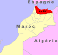
Fichier:Localisation du rif.png
Apparence
Localisation_du_rif.png (431 × 410 pixels, taille du fichier : 86 kio, type MIME : image/png)
Historique du fichier
Cliquer sur une date et heure pour voir le fichier tel qu'il était à ce moment-là.
| Date et heure | Vignette | Dimensions | Utilisateur | Commentaire | |
|---|---|---|---|---|---|
| actuel | 16 novembre 2021 à 12:46 |  | 431 × 410 (86 kio) | Enyavar | Reverted to version as of 13:41, 15 June 2008 (UTC) - those "corrections" are disputed and also have no impact on what is shown in the map; "Le Rif" appears to be north-morokkan |
| 30 septembre 2021 à 13:51 |  | 431 × 410 (84 kio) | KarimAohh | Reverted to version as of 17:52, 9 December 2016 (UTC) | |
| 30 septembre 2021 à 13:49 |  | 431 × 410 (86 kio) | KarimAohh | Reverted to version as of 20:49, 31 March 2016 (UTC) | |
| 9 décembre 2016 à 18:52 |  | 431 × 410 (84 kio) | Adharass | Reverted to version as of 14:47, 26 March 2016 (UTC) | |
| 31 mars 2016 à 21:49 |  | 431 × 410 (86 kio) | Fry1989 | Reverted to version as of 08:43, 26 March 2016 (UTC) | |
| 26 mars 2016 à 15:47 |  | 431 × 410 (84 kio) | Hpyounes | Reverted to version as of 22:14, 25 March 2016 (UTC) | |
| 26 mars 2016 à 09:43 |  | 431 × 410 (86 kio) | Ankry | Reverted to version as of 13:41, 15 June 2008 (UTC) | |
| 25 mars 2016 à 23:14 |  | 431 × 410 (84 kio) | Hpyounes | correction | |
| 15 juin 2008 à 14:41 |  | 431 × 410 (86 kio) | Monsieur Fou | {{Information |Description={{en|1=rif's map}} {{fr|1=Carte du rif}} |Source=travail personnel (own work) |Author=Monsieur Fou |Date=15 juin 2008 |Permission=toutes |other_versions= }} {{ImageUpload|full}} |
Utilisation du fichier
La page suivante utilise ce fichier :
Usage global du fichier
Les autres wikis suivants utilisent ce fichier :
- Utilisation sur fi.wikipedia.org
- Utilisation sur fr.wikipedia.org
- Utilisation sur ja.wikipedia.org


